A ‘multi-day severe weather event’ threatens large parts of the US with heavy rain and hail, tornadoes, and powerful supercell thunderstorms.
As California battles the worst snowstorm for a year, volatile weather driven by vast temperature differences across America is about to hit eastern states.
Heavy rain will bring a risk of flooding through the coming days before wind and hailstorms hit ahead of the weekend.
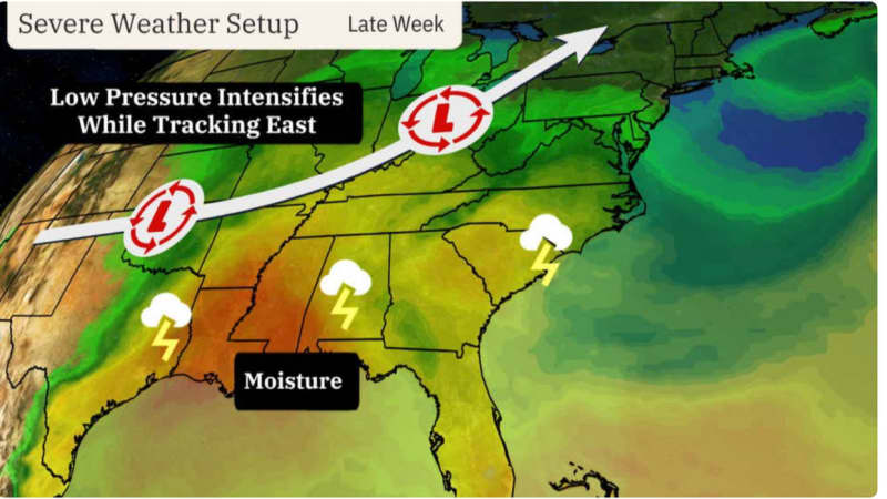
Low pressure sweeping eastwards on a strong jet stream will bring ‘multiple rounds of storms’, experts warn.

This could include supercell thunderstorms–strong storms with a tornado-like rotating core that form in unstable atmospheric conditions.
Weather Channel meteorologist Chris Dolce said: “A multi-day severe event is looking increasingly probable later this week.
“Severe weather could include tornadoes, large hail and the risk of wind damage, also a concern will be flooding with heavy rainfall to impact the south as multiple rounds of storms spread across the region this week.
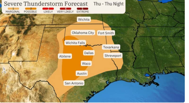
“A second round of stormy weather, including a potentially increased threat of severe storms will occur from Thursday through Friday.
“Supercells producing large hail, damaging winds and tornadoes are possible on Friday.”
Severe weather will be driven by a succession of weather systems crossing the US.
LATEST DEVELOPMENTS:
An unusually powerful jet stream, strengthened by temperature contrasts across the country, will steer the storms.
Southern states have seen temperatures rocket into the 90Fs over the past week as warm, moist air flooded in from the Gulf of Mexico.
Meanwhile, to the north and the northwest, cold Arctic air and heavy snow has brought California’s worst winter storm for a year.
Around 10 feet of snow blanketed parts of the region, with up to 12 feel possible by the weekend.
The focus for severe weather is now southeast storms, with Texas, Oklahoma, Mississippi, Alabama and the Florida Panhandle in the firing line.
Up to five inches of rain could hit the area through Saturday, sparking flood alerts for the weekend.
Mr Dolce said: “As a result, there could be a heightened risk of flash flooding in the region, especially from parts of southeast Louisiana, Mississippi and Alabama into Georgia and the western Carolinas by Friday and lasting into at least early Saturday.”
Severe weather will spawn from a ‘battleground’ formed by competing airmasses, experts say.
A cold front trailing low pressure cyclones will bring further mountain snow to California, according to the US National Weather Service (NOAA).
Jim Dale, US weather correspondent and senior meteorologist for British Weather Services, said: “There is a battle between the cold and very warm airmasses, and this is going to drive volatile atmospheric conditions as well as sweeping that warm air eastwards.”