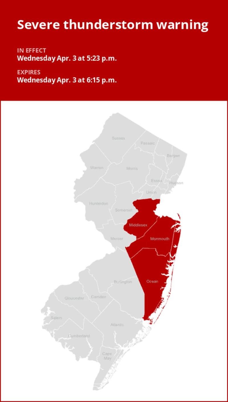
On Wednesday at 5:36 p.m. an updated severe thunderstorm warning was issued by the National Weather Service in effect until 6:15 p.m. for Middlesex and Monmouth counties.
The storms are expected to bring quarter-sized hail (1 inch).
"At 5:36 p.m., a severe thunderstorm was located over Lincroft, or near Long Branch, moving northeast at 50 mph," according to the weather service. "Minor damage to vehicles is possible."
The warning is for Long Branch, Sandy Hook, Middletown, Old Bridge, Marlboro, Manalapan, Tinton Falls, Holmdel, Red Bank, Matawan, Highlands, Brownville, East Freehold, Robertsville, West Freehold, Yorketown, Elberon, Navesink, Lincroft and Morganville. This includes Garden State Parkway between mile markers 105 and 123.
The weather service comments, "For your protection move to an interior room on the lowest floor of a building. Torrential rainfall is occurring with this storm, and may lead to flash flooding. Do not drive your vehicle through flooded roadways."
Lightning on the horizon: Expert safety measures for thunderstorms
Lightning strikes the United States approximately 25 million times each year, with the bulk of these electrical discharges occurring during the summer months. Tragically, lightning claims the lives of about 20 individuals annually, as reported by the weather service. The risk of lightning-related incidents escalates as thunderstorms draw near, reaching its peak when the storm directly looms overhead. However, it gradually recedes as the tempest moves away.
To ensure your safety during a thunderstorm, keep these recommendations in mind:
1. Lightning safety plan:
- When venturing outdoors, it's crucial to have a lightning safety plan in place.
- Monitor the sky for threatening signs and listen for the sound of thunder. If thunder is audible, it's an indication that lightning is nearby.
- Seek a safe place to shelter, preferably indoors.
2. Indoors safety measures:
- Once you're indoors, avoid using corded phones, electrical devices, plumbing fixtures, and stay away from windows and doors.
- These precautions help reduce the risk of electrical surges, as lightning can follow conductive pathways.
3. Wait for the all-clear:
- After the last lightning strike or thunderclap, wait at least 30 minutes before resuming outdoor activities.
- It's important to remember that lightning can strike even when a storm seems to have passed, so exercise caution.
When indoor shelter isn't available:
If you find yourself outdoors with no access to indoor shelter during a thunderstorm, take these steps to maximize your safety:
- Avoid open fields, hilltops, or ridge crests, which expose you to greater lightning risk.
- Steer clear of tall, isolated trees and other prominent objects. In wooded areas, stay close to lower stands of trees.
- If you're in a group, ensure that individuals are spaced out to prevent lightning current from transferring between people.
- Camping in an open setting during a thunderstorm is strongly discouraged. If you have no alternative, set up camp in a valley, ravine, or other low-lying areas. It's crucial to note that a tent provides no protection against lightning.
- Do not approach water bodies, wet objects, or metal items. While water and metal don't attract lightning, they conduct electricity effectively and can pose significant risks.
In summary, when facing the threat of lightning, vigilance and preparedness are your best allies. By following these guidelines, you can significantly reduce the chances of lightning-related accidents and prioritize your safety.
Rainy roadways ahead: Essential safety tips for heavy rain
When heavy rain strikes, safety is paramount. Equip yourself with these guidelines from the weather service to navigate wet roads and avoid hazards:
Beware of swollen waterways:
- During heavy rain, avoid parking or walking near culverts or drainage ditches, where swift-moving water can pose a serious risk.
Maintain safe driving distances:
- Adhere to the two-second rule for maintaining a safe following distance behind the vehicle in front of you. In heavy rain, allow an additional two seconds of distance to compensate for reduced traction and braking effectiveness.
Slow down and stay cautious:
- If it is raining and the roads are wet, slow down. Take your foot off the accelerator and let your speed drop gradually. Never use the brakes suddenly because this may cause the car to skid.
Choose your lane wisely:
- Stick to the middle lanes to minimize the risk of hydroplaning. Outer lanes are more prone to accumulating water.
Visibility matters:
- Enhance your visibility in heavy rain by activating your headlights. Be particularly vigilant for vehicles in blind spots, as rain-smeared windows can obscure them.
Watch out for slippery roads:
- The initial half-hour of rain is when roads are slickest due to a mixture of rain, grime, and oil. Exercise heightened caution during this period.
Keep a safe distance from large vehicles:
- Don't follow large trucks or buses too closely. The spray created by their large tires reduces your vision. Take care when passing them as well; if you must pass, do so quickly and safely.
Mind your windshield wipers:
- Overloaded wiper blades can hinder visibility. If rain severely limits your sight, pull over and wait for conditions to improve. Seek refuge at rest areas or protected spots.
- If the roadside is your only option, pull off as far as possible, preferably past the end of a guard rail, and wait until the storm passes. Keep your headlights on and turn on emergency flashers to alert other drivers of your position.
In the face of heavy rain, these precautions can make a significant difference in ensuring your safety on the road. Remember to stay informed about weather conditions and heed guidance from local authorities for a secure journey.
Advance Local Weather Alerts is a service provided by United Robots, which uses machine learning to compile the latest data from the National Weather Service.