By Jaka Hendra BaittriVinolia Ahmad


SOUTH PESISIR, Indonesia — Bendri lived with his wife and child just 80 meters, or 260 feet, back from the Surantih Mudiak Dalam River, which flows from Sumatra’s Barisan Mountains down to the Indian Ocean coast of West Sumatra province.
“There used to be a surau at the back here,” Bendri told Mongabay Indonesia at the ruins of his home, using the Malay word for an Islamic prayer hut. “It’s vanished — there’s no trace of it left.”
Extreme rainfall over Sumatra on the evening of March 7 triggered fatal flash flooding that killed at least 30 people in two districts of West Sumatra.
First responders arrived in Batu Balah, Bendri’s village, to find what looked like a war zone. Boulders and trees were carried downriver by the torrent, pulverizing homes and snatching lives in the village.

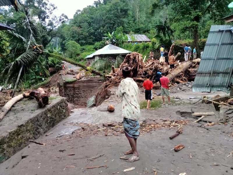
Houses in South Pesisir, West Sumatra, were hit by flash floods and landslides. Image by Jaka Hendra Baittri/Mongabay Indonesia.
Officials from Indonesia’s disaster mitigation agency, the BNPB, said the landslides and flooding had damaged 29,000 homes across West Sumatra’s South Pesisir district, which encompasses Batu Balah.
Moments before the flood destroyed Bendri’s home, the waves of mud, rock and debris smashed into the village of Langgai, located 5 kilometers (3 miles) upriver.
Outside the tent set up for evacuees, Langgai resident Ria cried and fainted. People picked her up and carried her back into the tent, her home since the disaster struck. The torrent killed her husband and other family members. Ria’s child, who studies in the nearby city of Bukittinggi, wasn’t in the village when disaster struck.
“Her father had also died recently, so she is traumatized and devastated,” said Nurma, a neighbor.
Local people and responders spent March 8 scrambling to find survivors buried under the mud, with volunteers in the village digging with bare hands out of desperation to find signs of life.
“It’s all gone,” said Langgai village official Raim Putra. “We’ve only got the clothes on our backs.”
Hamdani, a photographer who arrived in the village with first responders from the national search and rescue agency, known as Basarnas, emphasized the scale of the destruction in the two villages.
“There are boulders the size of houses in Langgai,” Hamdani told Mongabay Indonesia. “The Langgai mosque is gone.
“There’s no electricity, and there’s no clean water either.”
Those who survived were cut off for days after the extreme weather closed off the tracks and trails used to access the villages.
The aftermath of a village in Indragiri Hilir the worst impact of flash floods. Image by Vinolia/ Mongabay Indonesia.
Deforestation links
Data from the BNPB showed there were 5,400 disasters in Indonesia in 2023, including 591 landslides and 1,255 floods. That meant floods and landslides accounted for more than a third of disasters across the archipelago last year.
Indonesia’s volcanic terrain and intense rainy season often combine to produce fatal landslides and flash floods following cloudbursts. However, research on the ground and statements by public officials show that these risks are heightened by deforestation upland of disaster sites.
The root networks that trees construct underground improve drainage and bind topsoil together, stabilizing the landscape and lowering the risks of avalanches careening into communities like Langgai and Batu Balah.
The two villages lie on the fringe of Kerinci Seblat National Park, the largest protected forest in Sumatra and one of the last refuges of the critically endangered Sumatran tiger (Panthera tigris sumatrae).
Diki Rafiqi, who runs the advocacy unit at the West Sumatra office of Indonesia’s Legal Aid Institute (LBH), said data showed the area around the two villages had lost 1,410 hectares (3,484 acres) of tree cover between 2012 and 2022.
“The hills can no longer absorb the water,” Diki said. “The government should have been able to manage this disaster in advance by monitoring damage to the slopes and tackling illegal logging.”
West Sumatra’s disaster management lead, Rudy Rinaldy, said BNPB officers had found large pieces of timber across the disaster zone.
“I’d already suspected the flash floods that happened here were due to illegal logging,” Rudi told Mongabay Indonesia.
Three days after the rains began on the night of March 7, Indonesia’s minister of housing and public works, Basuki Hadimuljono, visited the scene of the disaster.
“I suspect there are two possible factors for this flash flood: illegal logging uphill, or extreme rainfall,” Basuki told journalists.

Large logs that accompanied the flood hit residential areas on the South Coast. Image by Jaka Hendra Baittri/Mongabay Indonesia.
Damages in South Pesisir were estimated at around 212 billion rupiah ($13 million), but that figure is likely to rise as more indirect costs are revealed.
Wengki Purwanto, West Sumatra director of the Indonesian Forum for the Environment (Walhi), a civil society organization, said officials should review regional zoning plans, including plantation and mining permits.
“The quality of the environment continues to decline from year to year, making South Pesisir one of the districts in West Sumatra worst affected by disasters,” Wengki told Mongabay Indonesia.
Yozawardi, head of the West Sumatra forestry service, said the steep valley and fragility of the topsoil elevated risks of landslides in the area.
“After we observed the forest cover there, it tended to be good, but there were several places where the land had been opened,” Yozawardi told Mongabay Indonesia. “The empty land was previously forested, then it was cut down and used for cultivation of gambier plants,” which are used as herbal medicines.
In Batu Balah village, Mongabay Indonesia spoke with Bendri in front of his gutted house filled with rubble and debris from the flood. The community’s homes and farmland have been destroyed.
Research shows climate change will increase the probability of extreme rainfall events as the atmosphere’s capacity to hold moisture increases.
Batu Balah farmer Reno was in the field when the flash flood struck. He picked his way over debris and waded through floodwaters to find his home in ruins.
Reno said he’d never seen a disaster like it. His neighbor Maraini, in her 80s, agreed as she surveyed the chaos of boulders and logs littering the valley.
“Never in my life has it been like this,” Maraini said.
Banner image: Bendri lost his house due to flash floods accompanied by wood and large stones in Batu Balah Village. Image by Jaka Hendra Baittri/Mongabay Indonesia
This story was reported by Mongabay’s Indonesia team and first published here and here on our Indonesian site on March 27 and 24, 2024.
This article was originally published on Mongabay