Put away the jackets at least for the start of the work week, because New Jersey is getting a summer preview Monday when temperatures are predicted to soar to the mid 80s.
“It’s the hottest day of the year in the Northeast and New Jersey, with temperatures into the mid-80s by mid-afternoon, " said Dominic Ramunni, a National Weather Service meteorologist in the Upton, New York, office. “It’s a little taste and teaser of summer.”
High temperatures could shatter records depending on the location, with a better shot at hitting new highs in Trenton than in Newark, meteorologists for the National Weather Service said.
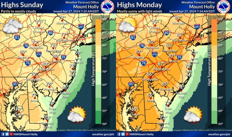
“It could be close for the daily record high out of Philly and a couple of places like Trenton,” said Alex Dodd, a National Weather Service Mount Holly meteorologist. “Their records are a little lower than other areas’ record temperatures.”
Trenton’s record high on April 29 is 88 degrees, which was set in 1974, and Monday’s forecast is for a high of 87, he said. Allentown, Pennsylvania, has a record of 86, which was also set in 1974. Monday’s predicted high is also 86, Dodd said.
Philadelphia’s record for April 29 is 90 degrees, set in 1974 and tomorrow’s forecasted high is 88.
“It’s within the realm of possibility of bursting that mark,” Dodd said.
Newark is less likely to break its 91-degree record set in 1974.
“The first 90-degree day doesn’t happen until May for Newark,” said Ramunni, the National Weather Service meteorologist from the Upton, New York, office. A high of 85 is forecasted for Monday, “so we are right on schedule in Newark,” he said.
You might want to think twice about sneaking in a beach day, however. Monday will see a sea breeze along the Jersey Shore making it cooler on the water, Dodd said. Temperatures are predicted to peak in the low- to mid-70s before noon, then drop back into 60s, he said.
The reason for the balmy temperatures is a southwest wind bringing warm air into the region, meteorologists said.
But it’s not going to hang around.
The mid- to upper-80s will drop to the 70s by later in the afternoon, Ramunni said.
By Tuesday, a cold front may bring showers and thunder from the west to northeast during the evening, Dodd said.
“It will not be prolific rainfall. There will be scattered showers and localized heavy downpours,” he said. “There may be a lingering shower on Wednesday, but the bulk of the week looks dry.”
Our journalism needs your support. Please subscribe today to NJ.com.
Larry Higgs may be reached at lhiggs@njadvancemedia.com. Follow him on X @CommutingLarry