By Kevin Damasio
Aquifers are vital for balanced ecosystems and human existence. While only 3% of the water on Earth is freshwater, almost 99% of that unfrozen volume is located in these geological formations. Despite their importance, little is known about the water that flows beneath our feet — almost always invisibly — and supplies rivers and lakes, especially during dry periods.
Drilling and monitoring wells are expensive and complex tasks, especially in continental countries, but they are also essential. According to UNESCO, groundwaters are the primary source for more than 2 billion people’s drinking water and for 25% of irrigated agriculture on the planet.
A new model developed by engineer geologist Clyvihk Camacho from the Geological Survey of Brazil (SGB), an agency of the Ministry of Mines and Energy, promises to refresh knowledge about the dynamics and state of aquifers by combining data from NASA satellites with artificial intelligence tools in order to identify variations in the volume of aquifers.
The model was validated with data from the aquifers where SGB’s Integrated Groundwater Monitoring Network (RIMAS) is stronger. In the process, Camacho found that two aquifers — the Urucuia in the Cerrado and the Bauru-Caiuá, which covers the Cerrado and the Atlantic Forest — lost 31 cubic kilometers (7.43 cubic miles) and 6 km3 (1.4 mi3) from 2002-21, respectively. The results were presented in the project’s first article, published in Water Resources Research, in August 2023.
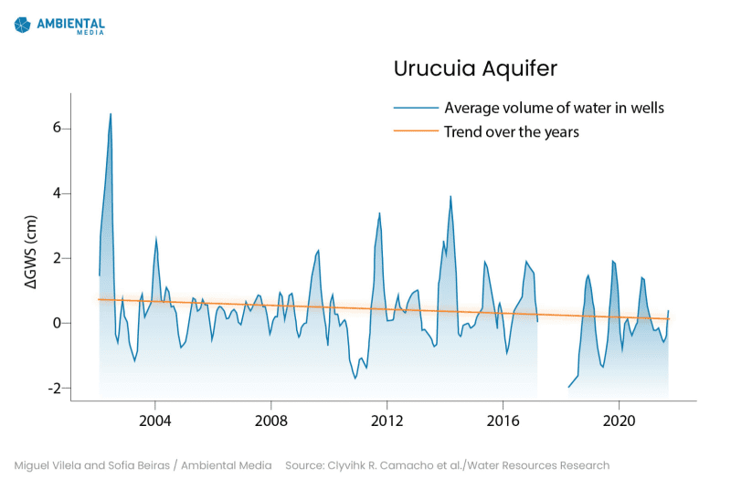
In the Urucuia aquifer, monoculture irrigation contributed to a 31-cubic-kilometer (7.43-cubic-mile) decrease in volume from 2002-21.
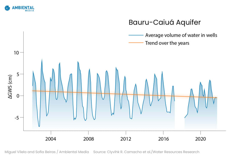
The Bauru-Caiuá aquifer lost 6 km³ of water in the same period, in a region of high use for agriculture and human supply, in the west of Minas Gerais.
“I developed this model because we need a better understanding of the behavior of groundwater in Brazil over time,” says Camacho, who conducts geosciences and hydrogeology research at the SGB. His work is the result of his Ph.D. in civil engineering at the Federal University of Rio de Janeiro. “A nation’s sustainable growth depends on having water – which is not equally distributed in Brazil – and the wisdom to use it.”
In Brazil, 68% of municipalities collect freshwater for public supply from deep wells, according to the Brazilian Institute of Geography and Statistics. Even so, current knowledge about Brazilian waters is based mainly on surface waters — rivers, flood plains, lakes and reservoirs.
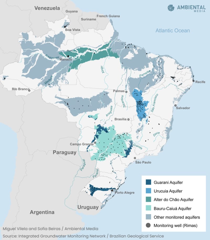
The National Hydrometeorological Network led by the National Water and Basic Sanitation Agency (ANA) has 13,148 fluviometric stations that monitor the flow of rivers. The RIMAS network, in turn, has 473 wells to monitor 24 sedimentary aquifers, which extend more than 2.84 million square kilometers (1 million square miles)) – a third of Brazil’s territory. Camacho, who is a member of the RIMAS team, considers the monitoring network to be the best tool for understanding aquifers, but “hydrogeological knowledge in Brazil needs to advance.”
Augusto Getirana, a researcher at NASA’s Hydrological Sciences Laboratory and one of the authors of the article, says Brazilian groundwaters remain “an unknown resource.” “Bangladesh, which is the size of Ceará state, has more than 1,200 groundwater monitoring wells; India is much smaller than Brazil and has over 20,000,” says Getirana, who was the adviser on Camacho’s Ph.D. dissertation.
“This work shows how we can use satellite data to obtain estimates of groundwater variability where there is no monitoring. But of course, having wells in those places would be ideal,” Getirana points out. To calibrate the model, scientists depend on data collected on site, such as that produced by RIMAS.
The Integrated Groundwater Monitoring Network (RIMAS) has 473 monitoring wells, a low number compared with other countries. Bangladesh, for example, which is the size of Ceará, has more than 1,200 wells. The problem is more pronounced in areas that are difficult to access, such as the Amazon.
The challenge of monitoring
The RIMAS network was created in 2009 at the SGB. The network installed wells in sedimentary aquifers located in recharge areas, where rainwater enters and undergoes level variation more quickly and clearly, in addition to being more sensitive and vulnerable to external pressures. Another priority criterion focused on locations with high use of groundwater.
At RIMAS’ wells, equipment records water levels by the hour. Every four months, SGB technicians go to the field to collect data generated in the wells and then calculate daily averages. The network plans to implement telemetry, which would allow it to monitor wells remotely, in real time.
“Water is a super important mineral asset, essential for any enterprise — manufacture, plantations,” says geologist and RIMAS coordinator Daniele Genaro. “The monitoring network provides this magnifying glass into water conditions when you want to set up a new project — whether or not it exists and is capable of meeting all demands. It’s an essential tool for observing groundwater over time.”
The aquifers with the largest number of monitoring wells are Urucuia (87), Bauru-Caiuá (71) and Guarani (41). According to Genaro, the new expansion points for the network are the Açu, on the border of Ceará and Rio Grande do Norte, and the Parecis, in Mato Grosso and Rondônia, where there is “an agricultural frontier that is growing a lot now.”
Genaro hopes to incorporate the model into the RIMAS network “as soon as possible,” after Camacho completes his Ph.D. studies. The system would allow, for example, to create virtual stations, which would reduce monitoring costs and fill gaps arising from problems in data generation or equipment. “The pandemic prevented us from doing field collection, so this allows us to generate the data to understand what happened during that period to complete the time series,” he adds.
“I think that’s the future. It won’t replace the physical monitoring network, but it’s a huge leap,” Genaro continues. “It’s an excellent tool to improve our density, with virtual monitoring stations, and if data is missing somewhere, to compensate for it with information from satellites.”
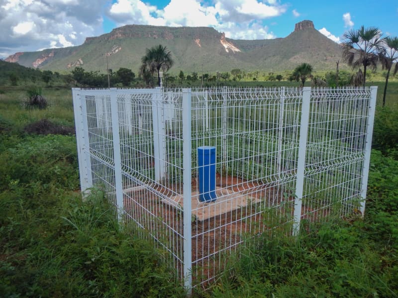
A well monitoring the Urucuia aquifer in the municipality of Mateiros, Tocantins. The Urucuia is Brazil’s most monitored aquifer, with 87 wells like this. Image courtesy of Marcio C. Abreu/Geological Survey of Brazil.
Hybrid model
The model is based on data from the Gravity Recovery and Climate Experiment (GRACE), a NASA remote sensing system that was based on satellites that measured the variation in Earth’s gravity to indicate changes in the planet’s water supply. However, the GRACE system did not distinguish the volume in each stratum of the water column — surface water, groundwater, soil moisture and snow.
Camacho then tested several artificial intelligence tools and combined them into a “joint hybrid model” capable of segregating the data and finding only the variation in groundwater. Finally, he conducted four experiments to compare the quality of the system with a well-established tool, NASA’s Global Land Data Assimilation System (GLDAS).
The two models were used to collect the same data from RIMAS’ monitoring wells, and the model developed by Camacho performed better in all experiments, as demonstrated in the article. “We saw that artificial intelligence performs better than robust and complex models, at a much lower computational cost,” Camacho notes. “By and large, the margin of error is around 1 centimeter (0.4 inches) of the water column within an aquifer. If it says that this aquifer gained 10 inches, it means 9.6 or 10.4.”
“We need to systematize Brazil’s hydrogeological knowledge, with monitoring for the entire national territory,” Camacho argues. In his view, the network could provide answers in extreme weather events such as the water crisis in Brazil’s southeast region in 2014 and 2015, and understand whether groundwater, under current conditions, would meet the various demands that emerge in a drought process.
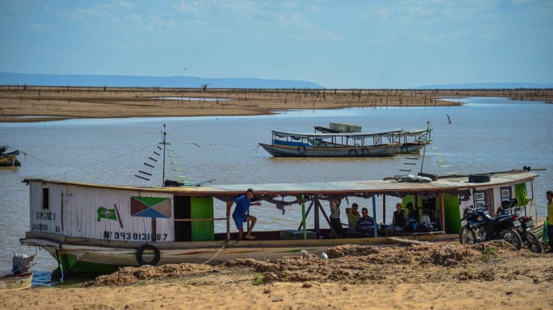
In 2015, the Sobradinho reservoir, supplied by the São Francisco River in northern Bahia, faced the worst drought in its history. In such periods, the Urucuia aquifer supplies up to 90% of the flow of the São Francisco. Image courtesy of Marcello Casal Jr./Agência Brasil.
Climate buffer
“Groundwater is a climate buffer. When it rains, much of it runs off into the rivers; some is retained in the soil and some goes to the aquifers,” Camacho explains. “This water that goes to the aquifers continues to flow slowly to lower regions and will eventually reach the river, in what is called base flow.”
If more groundwater is withdrawn than rainfall can recharge, the aquifer level will be lowered. This results, for example, in the loss of that interface with rivers and in migration of springs. The tendency to reduce river flow has led the RIMAS network to focus mainly on the Urucuia. This aquifer extends through more than 120 km2 [46 mi2] of the Cerrado, mostly in western Bahia, plus a fifth of the area divided into portions of Minas Gerais, Goiás, Tocantins, Piauí and Maranhão.
Sixty-seven of the 87 Urucuia wells are in western Bahia, where the aquifer’s recharge areas are in higher regions. Since the 1980s, a large amount of surface and underground water has been captured to irrigate monoculture plantations in these plateaus, mainly soybeans and corn. This has affected the hydrological cycle in the Grande and Corrente river basins, located above the Urucuia. “The intense activity in this region has further degraded the quality and decreased the volume of water sources,” states a RIMAS report.
The adverse effects are not limited to Bahia’s Cerrado biome, since the Urucuia’s base flow contributes 30% of the average annual flow of the São Francisco River, reaching up to 90% in periods of drought, when “it doesn’t rain much at its headwaters,” Camacho notes.
Along its 2,863 km (1,778 mi), the São Francisco crosses 505 municipalities in six states and suffers the effects of farming, dams, interbasin transfers and other circumstances. The consequence is that the river has not been reaching its regular mouth in the Atlantic Ocean, on the border of Alagoas and Sergipe, resulting in the phenomenon of saline intrusion, when the sea advances over the river channel.
The 31-km3 (7.43-mi3) decrease in the volume of the Urucuia aquifer over two decades coincides with the expansion of irrigated agriculture and vegetation suppression in western Bahia. This combination interferes with the natural dynamics of the vegetation and waters in Bahia’s Cerrado.
“We estimate that the renewable reserve — that is, the average amount of water that reaches the aquifer each year — is 24 km3 (6 mi3). So, this loss is greater than the volume that enters the aquifer in one year,” Camacho says. The Urucuia’s permanent reserve is 1,327 km3 (318 mi3) per year, according to ANA studies.
From 2001-22, 24,400 km2 (9,421 mi2) of native vegetation were lost in the municipalities of western Bahia, according to the National Institute for Space Research. MapBiomas, a multi-partner mapping initiative, points out that agricultural areas increased by 20,000 km2 (7,700 mi2) in the same period.
Based on the context of land use and occupation, Camacho’s article concludes that “water loss is driven by a prolonged drought across most of the country and intensification of groundwater pumping for irrigation.”
“We expect that the decrease in water levels is much more related to use patterns than to the climate process,” Camacho says, but the “very severe drought in 2015 and 2016” may be partly responsible.
The researchers calibrated the model using RIMAS’ figures on well levels for 2012-21. Then they were able to calculate volumes for 2002-11 using use satellite data. The decrease in the Urucuia’s volume had already been observed in RIMAS monitoring. “The general feeling is that the water level drops, then it recovers during the rainy season in the region but does not reach the same levels,” says Genaro, the geologist and RIMAS coordinator. “The aquifer’s recharge has not been as strong as its discharge.”
Losses and gains
The Bauru-Caiuá aquifer covers an area of 353,000 km2 (136,000 mi2) in parts of western Minas Gerais and Mato Grosso do Sul, São Paulo, Paraná, Santa Catarina and Rio Grande do Sul. It is the second formation with the largest number of RIMAS wells, due to its “economic importance and location.” As it is a large geological formation, the volume of water stored may vary depending on the region, but it is generally an aquifer “of good productivity, relatively shallow, and it is on top of the Guarani aquifer, so there is a direct relationship,” Genaro points out.
In its most recent report, RIMAS found “very low” recharge in 2021, “possibly due to rainfall levels below the historical average in virtually the entire region of this aquifer.” In 2022, the volume increased at the beginning of the rainy season, “followed by decreasing levels after these periods.”
In the article, the validation in the Bauru-Caiuá aquifer clearly demonstrated that the model is capable of distinguishing areas that gain or lose water within the same aquifer, using satellite data that indicate “volumetric variation over time.”
“In Minas Gerais, it is largely used for urban supply and irrigation, and there was less rainfall in some years, which caused supply to drop a little,” Camacho observes. “In the southern part of the aquifer, the Grande River flows down and reaches the Itaipu Dam area. Its reservoir raises the base level of the entire region, so the underground water supply is contained there; it doesn’t drain off much.”
Amazon aquifers
As the satellite is very large, Genaro says the joint hybrid model will be useful, firstly for monitoring larger aquifers where there is “greater concentration of water.” This characteristic helps tracking level variations and calibrating the models. That is the case in the Amazon region.
In the Amazon, the 2023 dry season produced shocking scenes. The largest river basin on the planet saw its rivers dry up due to the combination of warming in the equatorial areas of the Pacific and North Atlantic oceans, enhanced by climate change.
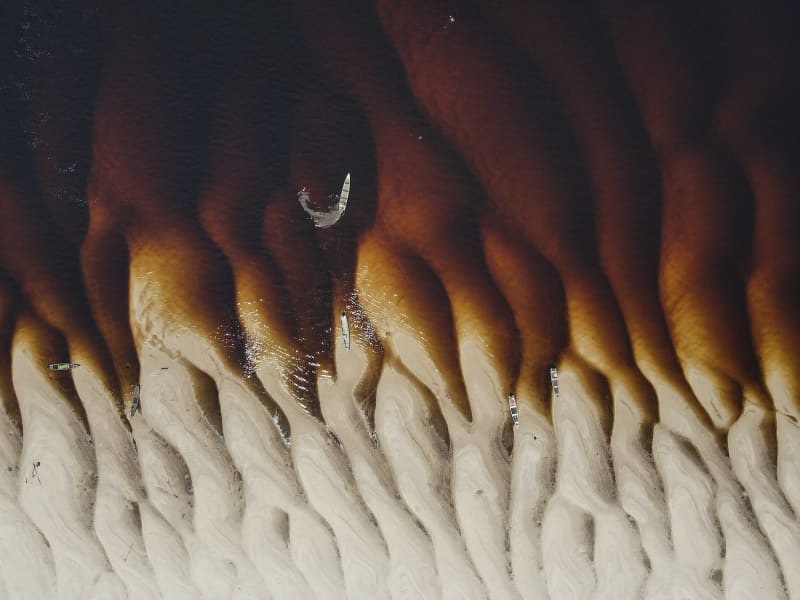
A section of the Negro River near the municipality of Barcelos, in September 2023, during a historic drought in the Amazon. Image courtesy of Bruno Kelly/Ambiental Media.
As a result, the Negro River reached its lowest recorded level in 121 years (12.7 meters or 41.6 feet) at the Port of Manaus on October 26; drought and high temperatures in the Solimões basin resulted in the death of 159 red dolphins and tucuxis; the Madeira River dried up to the point of suspending the operation of the country’s fifth-largest hydroelectric plant, the Santo Antônio dam, for 14 days; in the Tapajós River, an emergency was declared due to the impact on grain transportation through the waterway. But virtually nothing is known about the impacts of this extreme drought on Amazonian aquifers.
The Alter do Chão aquifer covers areas of Amazonas, Pará and Amapá states and is the most monitored aquifer in the Amazon. But it has only 16 wells “concentrated on the riverbank,” in cities or communities covered by the SGB. “In the Alter do Chão aquifer, we noticed that water levels began to drop, but not as strikingly and evidently as surface water,” Genaro observes. “Groundwaters somehow manage to protect themselves a little better.”
In other Amazonian aquifers, the reach of the RIMAS network is more limited, she recognizes. In the Içá aquifer, which covers a large portion of the state of Amazonas, the network has eight wells in a small area in Acre and Rondônia. There are five wells in the Boa Vista aquifer, in Roraima and four in the Trombetas, which stretches across a strip from Amazonas to Amapá.
Combining satellite images with artificial intelligence, the new model can fill some gaps. For example, it can signal strategic locations for expanding the number of monitoring wells, if abnormal level variations are found in areas that lack on-site monitoring. That is, it could result in a more effective expansion of the RIMAS network, especially in regions with less human occupation such as the Amazon or in agricultural expansion frontiers that require intensive irrigation; for example, the area comprising Maranhão, Tocantins, Piauí and Bahia, in the Cerrado, better known by the acronym Matopiba.
Surface waters already show signs of scarcity resulting from both extreme weather events and growing demands from farming and human supply. As a result, large agribusinesses have turned to aquifers, about which hydrogeological knowledge is still incipient in Brazil.
Therefore, Getirana, the researcher at NASA’s hydrological lab, advocates extensive monitoring of Brazilian groundwaters. We must have “at least a basic idea of how much water an aquifer can supply so as not to exhaust that resource,” observes the researcher who works in the laboratory of the American agency studying cases that already occur in Bangladesh, northern India and central USA. “Several examples around the world show that using groundwater as a frequent source of water for irrigation causes aquifer depletion.”
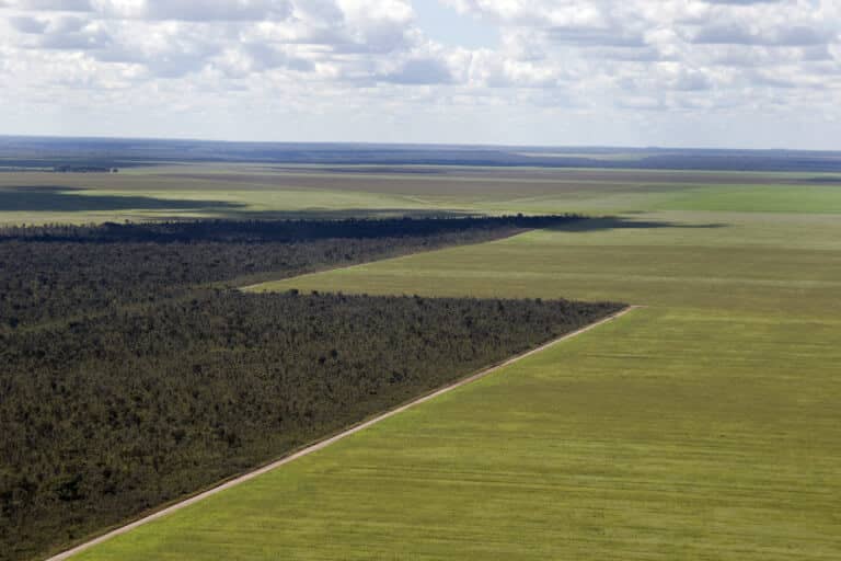
Banner image: Aerial view of unpaved roads dividing a soy monoculture from the native Cerrado, in the region of Ribeiro Gonçalves, Piauí, Brazil. Image courtesy of Adriano Gambarini/WWF-Brazil.
This content is part of a series of reports produced by Ambiental Media in partnership with the Serrapilheira Institute under project “Cerrado, o Berço das Águas” and was first published in Portuguese. The special report is at its development stage and includes analysis and visualization of data about the impacts of human actions on the main rivers of the planet’s most biodiverse savanna.*
This article was originally published on Mongabay