By Malavika Vyawahare


Robert Masolele says he remembers being struck by how small-scale farmers in his native Tanzania cleared large areas of forest to grow lucrative crops of cotton and cashews. In an interview with Mongabay, the remote-sensing expert describes how this awareness later prompted him to map deforestation in Africa with a focus on how commodity crops for export drive forest loss.
The research, published in the journal Nature Scientific Reports, yielded maps spanning 38 African countries. It’s an intricate and vast “tapestry,” as Masolele calls it, capturing in granular detail how humans make use of lands shorn of forests.
While there’s already published work on the causes of forest loss in individual countries, the application derived from the paper allows users to identify the individual drivers of forest loss in Africa and their relative contribution — including cash crops.
Masolele’s analysis showed that most of the deforestation across the continent is driven by small-scale agriculture. Madagascar and the Democratic Republic of Congo are hotspots for this kind of deforestation, with more than 85% of forest loss in these countries attributed to small farms.
But in countries like the Gambia, Niger, Sudan and Nigeria, Masolele found the largest swaths of woodland were cleared to create large-scale farms. In South Africa, the expansion of tree plantations constitutes a significant threat to native forests. In Somalia and South Sudan, forests are most likely to be cleared for pasture. Roads are intruding the most on Equatorial Guinea’s forests, while cacao is eating away into large tracts of forest in West Africa — not just in Ghana and Côte d’Ivoire, the world’s two biggest cacao producers, but also in Liberia. In Gabon, oil palm plantations are a threat to the green cover.
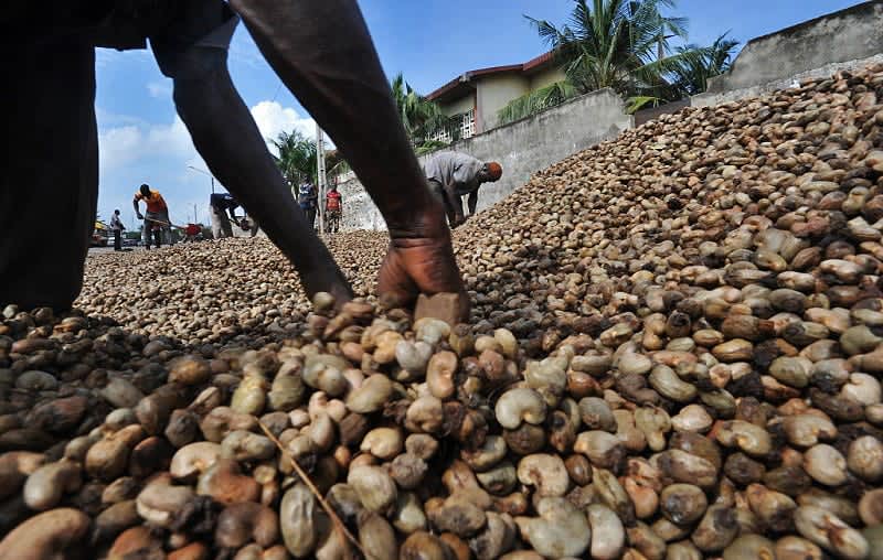
Preparing a cashew nut consignment for export. Image courtesy Tanzania Trade Portal (Fair Use).
Researchers are enjoying a newly enhanced ability to zoom into smaller parcels of land, resulting in a clearer picture of what’s happening on the ground. Remote sensing is often the only practical and affordable way to analyze large or hard-to-reach areas of the planet, or to assess changes over extended periods of time without returning on foot.
The team collected images of land use from 2001 to 2020 taken by a constellation of commercial satellites owned by Planet Labs. A The images are precise, with a 5-meter (16-foot) resolution. The Satellite Data Program of Norway’s International Climate & Forests Initiative funds free access to high-resolution imagery from Planet labs for researchers like Masolele to study forest loss and the impacts of climate change.
The next step was drilling into what prompted the clearing of forests. The researchers manually tagged deforested areas as resulting from one of 15 kinds of land uses, generating a reference data set that they then used to train an AI model. The model was then able to “read” and label satellite imagery from a much larger set of images.
“You see AI used more and more, especially with regard to classification where you’re getting an image and you’re saying what it’s likely to be,” said Sarah Carter, an ecologist and researcher at the World Resources Institute (WRI). “This study is unique in that they manage to classify so many different commodities.”
The team reported an average accuracy of 84% across the land-use classes they considered, ranging from agriculture to infrastructure. For some categories, the model’s precision was lower; for pasture, for example, it was closer to 65%. It performed quite well with two key commodity crops that are notoriously difficult to uncover because they thrive beneath tree canopies: cacao plantations were identified with about 90% accuracy, and coffee was successfully picked out around 80% of the time.
Masolele’s work is particularly relevant as the European Union prepares to implement the European Union Deforestation Regulation (EUDR) to stop commodities linked to deforestation from entering its common market. Starting Dec. 31 of this year, large companies must provide documentation showing that their imports are legally sourced and deforestation-free. Small and medium-sized enterprises will have until mid-2025 to comply.
The importance of the legislation adopted in May 2023 isn’t lost on Masolele, who is currently a postdoctoral researcher at the Netherlands’ Wageningen University & Research. Cacao, rubber, palm oil and coffee are among the land uses his team mapped for Africa; they’re all also among the commodities targeted by the EUDR. The legislation takes a due diligence approach: importers must take reasonable measures to ensure their production isn’t causing forest destruction, and install systems to segregate and trace deforestation-free goods as they traverse supply chains.
In 2022, African nations supplied about 70% of the EU’s cocoa bean exports, one of the commodities included in the EUDR (cocoa is produced from roasting and grinding cacao tree seeds). Côte d’Ivoire and Ghana in West Africa, as the top exporters, are also nations suffering rapid forest loss.
Zoltan Szantoi, a remote-sensing expert at the European Commission’s Joint Research Centre, says the newly published research makes a strong contribution to mapping deforestation across Africa: “They are going in the right direction using state-of-the-art processing algorithms.” He notes, however, that it won’t be directly useful for implementing EUDR because it relies on data from 2001 to 2020.
Per the new rules, commodities produced on land deforested after Dec. 31, 2020, can’t enter the EU. So cocoa sourced from land cleared of forests in 2019 won’t run afoul of the bloc’s regulations. Masolele says they’re planning annual updates to the land-use product available online.
In general, satellite imagery and models based on that are unlikely to be used as clinching evidence in courts because they don’t promise accurate results all the time; they can only guide compliance.
Regulators won’t set out to verify every batch of imported goods. The EUDR will rely on self-reporting by companies. The responsible authorities in importing countries will only attempt to verify this information only where red flags appear. For example, a company importing large shipments of cocoa from China could come under suspicion because the country is not a known cocoa producer. “The data from this paper can be used as a baseline to understand the hotspots of different commodity crops going back in time,” Masolele says.
Commodities from certain countries will be more likely to be subject to checks. In one of the more controversial parts of regulation, the EU plans to classify countries as being of low, standard or high risk based on factors like pace of deforestation and rate of agricultural expansion. Countries of origin deemed to be high risk will face more stringent requirements, including more frequent inspections. The EU Commission is expected to publish the categorization by year’s end.
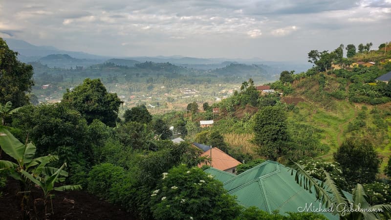
Coffee plantations spread across a village in Uganda. Image by Michael Gabelmann via Flickr (CC BY-NC 2.0).
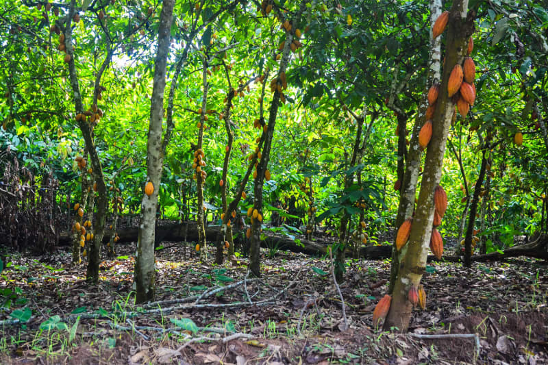
A cacao plantation in Cameroon. Masolele’s analysis showed that most of the deforestation across the continent is driven by small-scale agriculture. Image by jbdodane via Flickr (CC BY-NC 2.0).
Some supplier countries have expressed concerns the regulation unfairly penalize them. They risk being shut out of the market because businesses could start sourcing raw materials from countries deemed less risky, or where it’s easier for them to show compliance. This could hit export revenues and, ultimately, the livelihoods of growers. There are also fears that the costs of compliance will be borne by smallholder cultivators who sit at the bottom rung of the supply chain for crops like cacao and palm oil.
As momentum grows to clean up supply chains the world over, other nations will also be seeking more high-quality data about the true costs of the goods they consume. Countries like the U.S., one of the major importers of goods driving forest loss overseas, is exploring similar curbs. Masolele says they plan to use the model to generate maps for other regions like Latin America and Southeast Asia.
Banner image: Joseph Kirimbwa, a coffee farmer in Uganda and a member of a Nespresso program that hires and manages coffee plantations in Africa. Image by Budiey via Flickr (CC BY-NC 2.0).
Citation:
Masolele, R. N., Marcos, D., De Sy, V., Abu, I., Verbesselt, J., Reiche, J., & Herold, M. (2024). Mapping the diversity of land uses following deforestation across Africa. Scientific Reports, 14(1). doi:10.1038/s41598-024-52138-9
This article was originally published on Mongabay