A ‘tornado surge’ whipping up more than 700 hulking twisters since autumn threatens to rage into summer.
Ferocious storms driven by an active jet stream and clashing tropical and polar air masses will unleash heavy rain, hail and thunder through this week.
Reports reveal the tally of tornadoes to hit America’s infamous tornadoes alley this year to have smashed the average by around 100.
Tornadoes are most common between April and June, after which the United States’ hurricane season roars into action.
AccuWeather chief meteorologist Jon Porter said: “Recent rounds of severe weather and tornado outbreaks across the United States have sent the number of tornado reports surging above the historical average for this time of year.
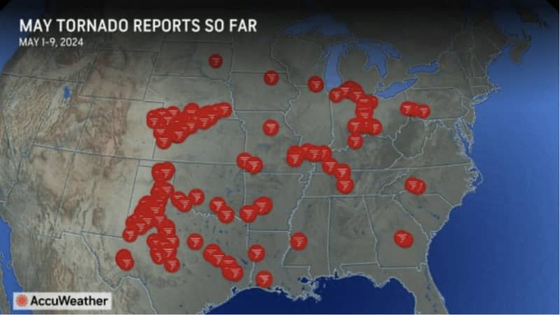
“Roughly 700 preliminary tornado reports have been filed so far this year.
“These recent tornado outbreaks show just how important it is for everyone to be prepared, have a safe space ready, and to immediately get to shelter every time a tornado warning is issued in your area.”
Tornado alley records around 550 tornadoes a year, although around 500 have been logged since the start of April.
This year is likely to be beaten in numbers by only four previous seasons–2007, 2008, 2011, and 2017.
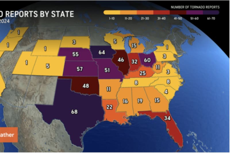
Worst affected have been Ohio, Texas, Iowa, Kansas, and Nebraska, according to AccuWeather.
Meteorologists have urged people not to ‘let their guard down’ as the threat of severe storm rages on.
LATEST DEVELOPMENTS:
Mr Porter said: “Receiving repeated rounds of warnings in the same areas can be frustrating.
“But stay aware of what’s happening, especially when there are severe storms forecasted during the overnight hours when most people are sleeping.”
As temperatures rocket in the south this week, a surge of tropical air will collide with Polar air to the north.
This will trigger further unsettled weather, particularly at the boundary, including the Gulf Coast and the southeast.
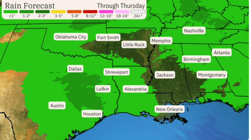
Weather Channel meteorologist Jonathan Belles said: “This week in the south, a wet pattern will continue, and heavy rainfall may trigger flash flooding.
“Scattered severe storms are possible and a pair of systems this week will bring wet weather to parts of the South, the Midwest and the East.
“On Wednesday, the Carolinas and portions of the Florida Peninsular might see a few severe storms.”
Heavy rainfall will be the greatest threat ahead of the weekend, he warned, with flooding possible in Texas and the lower Mississippi Valley.
He added: “By Friday, the risk of severe thunderstorms and flooding rainfall will spread to the northern Gulf Coast region.”
The unusually active storm season has been driven by a ‘conveyor belt’ of heat and humidity from the Gulf of Mexico.
Jim Dale, meteorologist for British Weather Services and co-author of ‘Surviving Extreme Weather, said: “We are still very much in tornado season, and this is being fuelled by a conveyor belt of heat and humidity coming in from the Gulf of Mexico.
“This is probably going to continue through the coming week and beyond as hot and cold air masses clash.”