A barrage of tropically charged super-thunderstorms will erupt in a ‘ring of fire’ circling a deadly 110F heat dome.
Torrential downpours, floods and giant hailstorms hurled from churning tornadoes will keep the US’s storm misery raging through the start of June.
America’s National Weather Service has issued a battery of warnings and alerts for extreme heat, flooding and high winds.
Violent storms will flare around a giant heat dome–a body of high pressure–pushing temperatures across the country to record levels.
A spokesman for AccuWeather said: “Storms tend to erupt along the edge of a heat dome, and a heat dome over Mexico likely contributed to the frequency of torrential downpours and severe thunderstorms in the central United States in recent weeks.
“This is because storms and downpours cannot erupt in the middle of the massive area of sinking air which exists under the heat dome.
“Instead, the storms tend to erupt on the edges or areas of least resistance or where the air can rise more freely, a phenomenon that can be called the ‘ring of fire’.”
The heat dome will shift northwards into the United States through the coming weeks driving extreme heat.
Southern and south-western states will be in the firing line while scorching air meeting cool air to the north will drive storms.
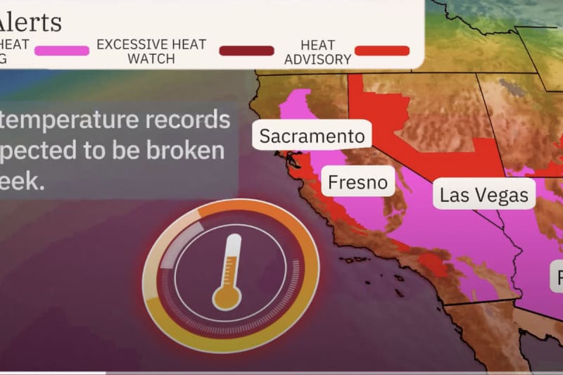
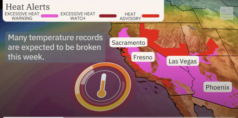
Extreme heat has started to scorch parts of California, Nevada and Arizona with temperatures in the low-100Fs.
People with health conditions should take extra care with tumbling temperature records threatening an increased risk of heat illness.
Weather Channel meteorologist Briana Waxman said: “A ridge of high pressure will create a dome of hot air over the western US this week putting many at risk of heat illnesses.
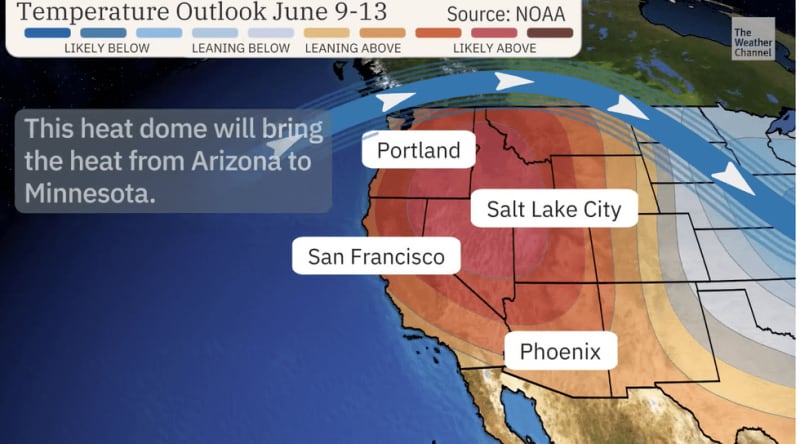
“The heat will extend across the region but will be most intense in the southwest.
“Night-time temperatures will also remain warm, so opening the windows to cool down at night won’t be effective.
“Heat concerns will expand into the northwest on Friday, and daily records are expected to fall.”
Severe thunderstorms will target the Upper and Middle Mississippi Valley and Central Plains, unleashing ‘damaging gusts’, ‘large hail’ and floods, according to NOAA.
Severe weather will persist through to the end of the week as extreme heat builds from the south, it warned.
A spokesman said: “A pair of low-pressure systems tracking across the eastern half of the country will trigger scattered to isolated showers and thunderstorms across much of the region before shifting into just the East Coast on Thursday.
“There are ‘Excessive Heat Warnings’ in effect for California's Central Valley as well as portions of the Desert Southwest including south-eastern California, southern Nevada and western and southern Arizona.
“Mild night-time temperatures will continue to plague southern Texas through the end of the week.”
The meeting point of cold and hot air will spawn an assault of tornadoes and thunderstorms, experts warn.
Jim Dale, US weather correspondent and meteorologist for British Weather Services, said: “There is still cooler air to the north, and when this meets with the hot plume, all the ingredients are there for thunderstorms and the ongoing risk of tornadoes.
“The heat is going to build through the start of the month, and already high temperatures will reach dangerous levels through summer.”