A ‘significant heavy rain event’ driven by a relentless spate of storms sweeping America have put almost 15 states at risk of flooding.
Torrential downpours threaten more than half a foot of rain in parts as saturated ground reaches tipping point.
Swaths of the United States are braced for another round of storms ahead of the weekend with Florida on tornado alert.
Colliding air masses combined with climatic events including the potential transition from El Nino to La Nina are blamed for the volatile weather.
Jim Dale, meteorologist for British Weather Services and US weather correspondent, said: “Flooding is going to be a risk particularly across southern states as a developing low comes out of the Gulf of Mexico.
“This is part of the transition as the very warm and humid air comes up from the south and meets the cooler air to the north which can drive volatile conditions.
“We are also coming to the end of a strong El Nino, and this could have an impact on the storm and hurricane season going through the rest of the year.”
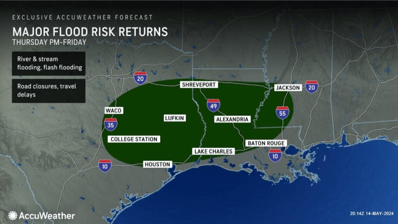
Bands of torrential rain will bring the greatest risk of flooding to the south, from East Texas to Florida, experts say.
"Urban flash flooding" is expected to cause travel disruption while threatening damage to property and "risk to life".
Heavy rain has pushed groundwater levels to maximum capacity and left rivers and streams at bursting point.
LATEST DEVELOPMENTS:
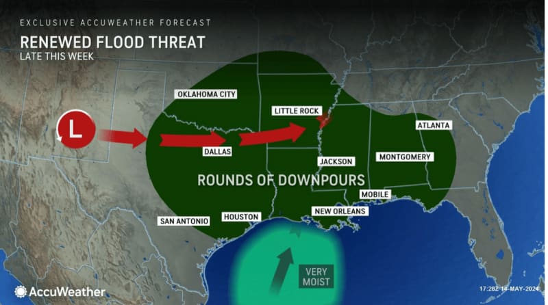
AccuWeather meteorologist Alex Sosnowski said: “If you live along rivers or streams anywhere from eastern Texas all the way over to Mississippi, Alabama, and even Georgia, you will need to watch water levels closely for the next seven to ten days because the rainy pattern is far from over.
“Where these rainfall events overlap is where you’re going to have the most significant risk of rising water levels and flooding.
“A zone from eastern Texas, through central Louisiana, and central Mississippi could see four to eight inches of rainfall.”
The US National Weather Service (NOAA) has flood advisories and coastal flood advisories in force in Nevada, Idaho, Colorado, Texas, Iowa, Missouri, Illinois, Louisiana, Tennessee, Carolina, Virginia, Arkansas, Kentucky, Alabama and New England.
A separate tornado watch warning is in force in Florida which is expected to take the worst twister hit.
A NOAA spokesman said: “With the return of the heat there will also be an environment that will be very conducive for widespread heavy rainfall for the Gulf Coast, Southern Plains and Lower to Mid-Mississippi Valley which could be a potentially significant heavy rain event.”
Temperatures could hit 100F across southern states as hot air floods in from the Gulf of Mexico, the NOAA warned.
It added: “Across South Florida, persistent south-westerly winds ahead of an approaching mid-level ridge axis will set the stage for very warm weather, with heat indices exceeding 100 degrees possible.
“Localized Major heat-related impacts are possible with this round of hot weather through the work week according to experimental NWS ‘HeatRisk’ guidance.”
Violent weather conditions coincide with the official start of the Eastern Pacific hurricane season.
Weather Channel meteorologist Chris Dolce said: “In addition to Mexico and Central America, hurricanes and tropical storms in this basin can affect the southwestern United States.”